One of the outstanding geological sites in southeastern Minnesota is Barn Bluff (He Mni Can to the Dakota, La Grange to the early French explorers*) in Red Wing. The bluff is a bedrock island oriented roughly east–west, adjacent to the Mississippi River just above the Lake Pepin section. If you were to have gone back to the early postglacial period, it would have been a literal island thanks to meltwater filling the Mississippi River valley.
*All of the names are kind of prosaic, actually. "He Mni Can" is "hill, water, wood", "La Grange" or "Lagrange" is "the barn" for its general shape, and the English name is just a translation of the French.

|
|
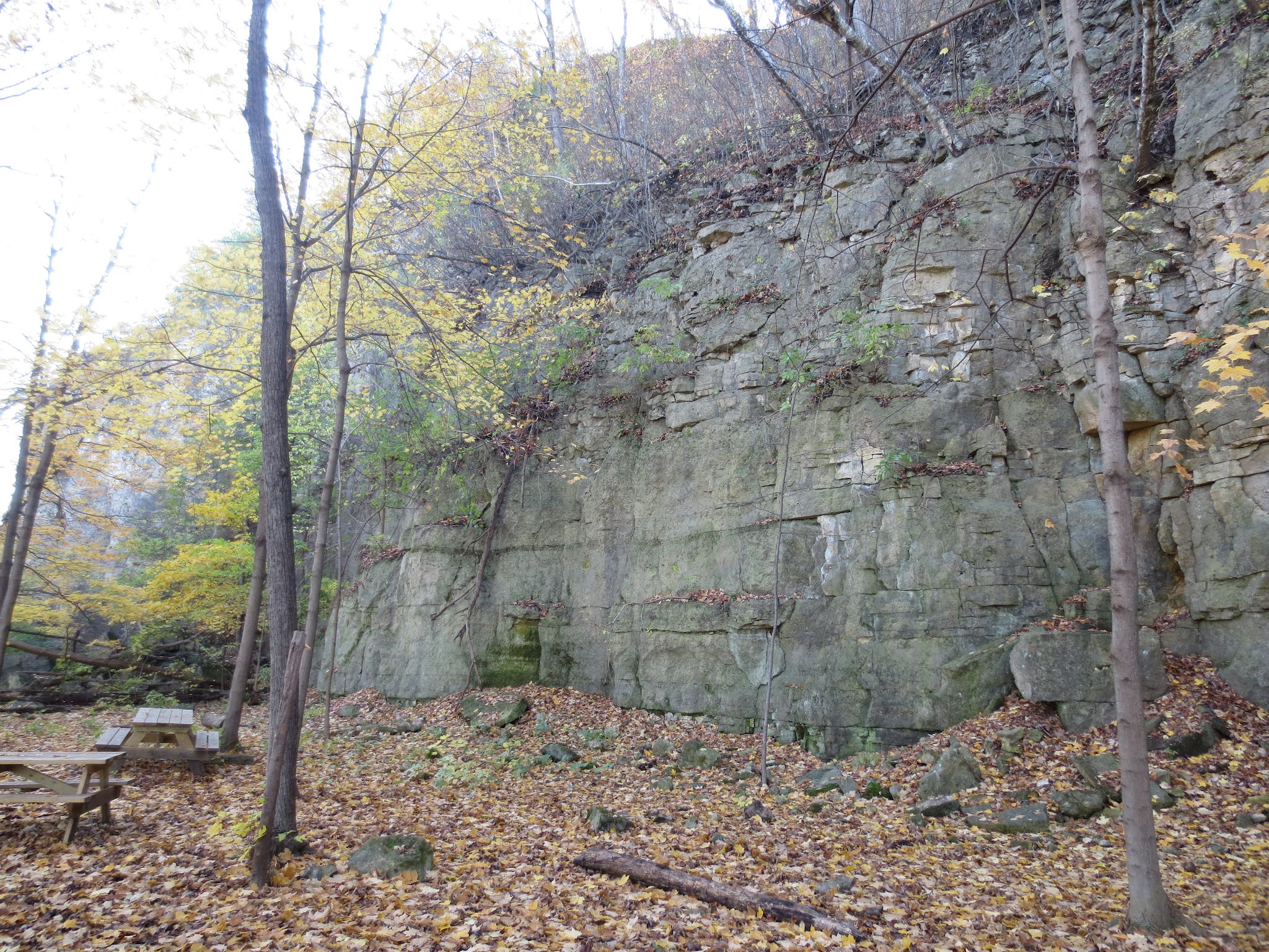
The view of the south side of the west end. Observant eyes may notice
that the color of the lower outcrops change near the left side of the picture,
from orangish on the left to banded green on the right. Read on for
why! |
The bluff is a regional park (as well as being on the National Register of Historic Places), and is circled by trails that connect a pair of overlooks at the east and west ends. The overlooks take advantage of the uppermost bedrock, our old friend the Prairie du Chien Group. Since we've also got a typical Cambrian sequence just below, we can be confident we're looking at the lower Prairie du Chien (i.e., Oneota). The bluff also includes, in descending order, the Jordan Sandstone, St. Lawrence Formation, and a visibly glauconitic phase of the Tunnel City Group (old Franconia Formation). These aren't visible from the trails, though; the Prairie du Chien is what you'll see up there.

|
|
From the overlook at the west end, looking southwest. |

|
|
From the east overlook, looking southeast. |
Back in the day, the bluff was quarried for the Prairie du Chien rock, and there is evidence of this activity on both the north side (which has a "quarry trail") and the south side. Today the sturdy carbonates are much more popular for rock climbing.

|
|
The old quarry on the south side. |
|
|
Part of the quarry trail on the north side. |
The Prairie du Chien can sometimes seem kind of monotonous, but if you sit with it for some time you'll start to pick up variations. Sandy intervals, zones of planar bedding, chert nodules, and other features are present here.

|
|
Part of a sandy interval, with some vertical tubular features near the center
that resemble perhaps finger-thick burrows. |

|
|
A large chert nodule is just left of the scale bar. |

|
|
Not sure what's up with the green band about 2/3–3/4 of the way up the
photo. |
If we're talking Prairie du Chien, surely there must be stromatolites involved here somewhere, right? I have seen a couple here. The catch is the vertical walls and surficial weathering; there's a lot of rock but you only get to see so much.

|
|
Looks like some stromatolitic action to me. |

|
|
Seen on a previous visit, with nickel for scale. |
I also observed some odd features that I wasn't sure about, including circular molds in a stone from the sandy interval and whatever the heck the wormy blebs are.

|
|
This turned out disappointingly blurry, but there are multiple ring-like
molds in this sandy Prairie du Chien block. The photo makes them look a
bit more helical (and therefore more snail-ish) than I thought they
looked in real life (more flat and crinoid-ish). |

|
|
Some kind of burrows, or weathering feature, or burrows
accentuated by weathering? |
Also, I don't know where the stone for some of the steps came from, but it's classically "fucoidal" (maybe Prairie du Chien from the Minnesota River valley?).

|
|
X marks the spot? |
Barn Bluff is also famous for displaying the Red Wing Fault, a normal fault that resulted in most of the rocks of the bluff being down-dropped relative to a smaller section on the south side of the bluff. Take a look at the first photo again. You're seeing, mostly, the Tunnel City Group (the green banded part of the exposure). The Prairie du Chien at the top is on the other side of the fault. We can see what's supposed to be underneath the Prairie du Chien in normal circumstances if we circle around to see the west end:

|
|
The Jordan Sandstone. |
Unfortunately, putting hand on fault is not the most convenient thing, as it requires negotiating a couple of major highways. It is certainly quite possible to observe and appreciate the difference in lithology from a bit farther back, though.

|
|
For example, orange Jordan on left, green Tunnel City on right. |
The bluff was first documented geologically in Shumard (1852), where it was identified under the older "La Grange". This name hung on in the literature for a while (e.g., Hall 1863, Walcott 1914, Nelson 1956), and has shown up more recently as well (Hughes 1993, 1994). Anyway, Shumard on page 499 gave a stratigraphic section for the bluff. It's not immediately obvious, but the column is in reverse order of what you might expect, i.e., the base of the column is at the top of the description and the top of the column is at the bottom of the description. Units 1 and 2 of his section appear to refer to the Tunnel City Group, 3 through 5 appears to be the St. Lawrence Formation based on the references to dolomite, 6 is the Jordan Sandstone, 7 is covered, and 8 is the Prairie du Chien Group. These, incidentally, indicate that Shumard saw the river side, because the other side would have been much different thanks to the fault. If you really want to get into the stratigraphic weeds, there's a dissertation, McGannon (1960), that worked on reorganizing the St. Lawrence the way that previous U of MN dissertations had reorganized the "Franconia", only it didn't catch on. This dissertation blew up the St. Lawrence as it was then understood, including creating a new "Stockton Hill Formation" with the "Redwing Member" as its upper unit. The bluff would have been the type locality.
Shumard noted the presence of fossils in several intervals, including brachiopods in the Tunnel City Group, and brachiopods, trilobites, and echinoderm columnals in the St. Lawrence Formation. Walcott (1914) gave a longer faunal list for the St. Lawrence as his locality 113, adding a helcionelloid (Owenella vaticina) and the enigmatic Serpulites murchisoni. A few fossil species have been named from specimens collected at the bluff: Dikelocephalus pepinensis (Owen 1852; now Saukiella), Dikelocephalus marginatus (Ulrich and Resser 1930; now considered a synonym of D. minnesotensis), and Triarthrella auroralis (Hall 1863). Of course, the occurrences are all lower in section than the Prairie du Chien, and not quite as accessible today.
References
Hall, J. 1863. Preliminary notice of the fauna of the Potsdam Sandstone. Sixteenth Annual Report of the Regents of the University of the State of New York on the Condition of the State Cabinet of Natural History:119–226.
Hughes, N. C. 1993. Distribution, taphonomy, and functional morphology of the Upper Cambrian trilobite Dikelocephalus. Milwaukee Public Museum Contributions in Biology and Geology 84.
Hughes, N. C. 1994. Ontogeny, intraspecific variation and systematics of the Late Cambrian trilobite Dikelocephalus. Smithsonian Contributions to Paleobiology 79.
McGannon, D. E., Jr. 1960. A study of the St. Lawrence Formation in the Upper Mississippi Valley. Dissertation. University of Minnesota, Minneapolis, Minnesota.
Nelson, C. A. 1956. Upper Croixan stratigraphy, Upper Mississippi Valley. Geological Society of America Bulletin 67(2):165–183.
Owen, D. D. 1852. Report of a geological survey of Wisconsin, Iowa, and Minnesota; and incidentally of a portion of Nebraska Territory. Lippincott, Grambo & Co., Philadelphia, Pennsylvania. Available at https://archive.org/details/mobot31753000174885 (plates not included), https://archive.org/details/reportofgeologi00owen (full plates), or https://books.google.com/books?id=Y_ZYAAAAYAAJ.
Shumard, B. F. 1852. Geological report of local, detailed observations, in the valleys of the Minnesota, Mississippi, and Wisconsin rivers, made in the years 1848 and 1849, under the direction of David Dale Owen, United States Geologist, by B. F. Shumard, head of subcorps. Pages 481–531 in Owen, D. D. Report of a geological survey of Wisconsin, Iowa, and Minnesota; and incidentally of a portion of Nebraska Territory. Lippincott, Grambo & Co., Philadelphia, Pennsylvania. Available at https://archive.org/details/mobot31753000174885 (plates not included), https://archive.org/details/reportofgeologi00owen (full plates), or https://books.google.com/books?id=Y_ZYAAAAYAAJ.
Ulrich, E. O., and C. E. Resser. 1930. The Cambrian of the Upper Mississippi Valley. Part I, Trilobita; Dikelocephalinae and Osceolinae. Bulletin of the Public Museum of the City of Milwaukee 12(1):1–122.
Walcott, C. D. 1914. Cambrian geology and paleontology II. No. 13. Dikelocephalus and other genera of the Dikelocephalinae. Smithsonian Miscellaneous Collections 57(13).
No comments:
Post a Comment