I was recently on a trip to southeastern Minnesota for several days. While there, inevitably I ended up with some geological photos. I must confess that I've never spent any time down here outside of passing through, and this was actually the first occasion I'd spent any time above the Cummingsville, so it was nice to see the overlying units I'd only read about before. If you'd like to know what we're up against, I recommend the Minnesota Geological Survey's geologic atlas of Fillmore County (the trip wasn't entirely in Fillmore County, but you'll get the idea).
Showing posts with label Prairie du Chien. Show all posts
Showing posts with label Prairie du Chien. Show all posts
Saturday, August 2, 2025

Monday, February 26, 2024
Stromatolites in situ
A few weeks ago, during the elongated-dry-autumn-with-long-nights that has been substituted for winter in these parts this year, I visited a stromatolite patch in the Prairie du Chien Group and took the usual digital heap of photographs. The photos aren't quite as sharp as I would have liked, but they show a variety of aspects of stromatolites both up close and in situ, unlike the usual circumstances of getting only one of those two properties.
First off, here's a general idea of what we're dealing with:

|
|
Click to embiggen, as usual; the thing about stromatolites is sometimes
they're more apparent at a distance, and sometime they're more apparent
when your nose is practically on them. In this photo, there are columns
a couple of centimeters across in the lower part, leading to a small
shelf with a knobbly surface representing the tops of said columns,
followed by an interval of more obscure growth. |
The prolific interval was up to about three quarters of a meter thick, with some significant variation, microbial mounds not being big on standardization. Within this interval it was possible to see where a mound's growth had been cut off, or changes between narrow columns and broader stacks.

|
|
Here we have a broad mound of numerous coalesced small centers that is
cut off starkly about two-thirds of the way up the photo. |

|
|
Another example where there appears to be discontinuity between the
growth lower in the photo and that in the upper part. |

|
|
This tall mound is fairly broad at the base, then goes into narrower
columns, then appears to show column consolidation near the top. |
Part of why the photos may have lacked some clarity is the weathering of the surfaces (and the bright light). The stromatolites had a sort of artistic appearance in places, a bit like fingerprints in rock. I could see paintings of these done with heavy strokes to emphasize the tactile appearance of weathering layers.

|
|
There's a certain melted quality to this exposure. |

|
|
I'm not sure what happened here, but this one looks like it's breaking
up (and there seems to be a big rounded pebble in the upper left). |
Another interesting feature was the occasional exposure of the top surface of a stromatolitic interval. Given the preponderance of smallish columns, it should not come as a surprise that such surfaces are knobbly.

|
|
A close look will reveal the more or less concentric layers of
individual columns that have been truncated by weathering. |
Finally, here's a surface showing columns that apparently grew out laterally. We usually think of the original microbial colonies growing vertically, to reach the light, but again microbial mounds aren't big on standardization, and will grow as conditions influence them. (Or maybe this mound was simply knocked over at some point; unfortunately, we're missing most of it.)

|
|
Preservation is different in this one as well, with layers still being
evident but expressed less colorfully. |
Sunday, February 12, 2023
Hunting the wild stromatolite at Vermillion Falls
The gorge at Vermillion Falls, as seen before, is cut through quite a bit of the Prairie du Chien Group. Therefore, it is entirely reasonable to suppose that somewhere in all of those oodles of outcrop, there are some stromatolites. It should be just a matter of walking down and having a look, right? We-e-ll, easier said than done. A few factors are pushing against going from "predicted" to "established":
1) The classic booby prize of vertical exposures—sure, there's a lot of surface, but you don't get to see most of it up-close;
1b) Furthermore, for many of the places where you *can* examine the walls, you can't change your vantage point because backing up a foot or two puts you a foot or two lower or in open space (and that never helps). What makes this annoying with stromatolites is they can be expressed in various scales, and what you can't see with your nose on the rocks may be perfectly apparent from a couple of arm's lengths away except for that whole "absence of footing" thing, or a promising feature may disappear as you clamber up the slope to inspect it;
2) The surfaces have been fried to a crisp by weathering, which for our purposes disguises the fine layering and other subtle features.
The existing literature is not especially illustrative. Stauffer and Thiel
(1941) included a section taken at the railroad bridge (now a footbridge),
which describes the walls as 58.5 ft (17.8 m) of Shakopee Dolomite over 1 ft
(0.3 m) of Root Valley Sandstone over 47 ft (14 m) of Oneota Dolomite, with
nary a stromatolite mentioned (to be fair, the lithological descriptions are
also very slim). The site has made it into a few theses and other student
papers (Shea 1960; Squillace 1979; Robins 2005), but that seems to be about
it. Maybe this limited documentation is a recognition of the above limitations
by wiser heads than mine, but I have the faith of a gambler that
something will turn up if I look long enough, so down we go back into the
gorge.

|
|
Besides, why would I want to sit around inside when I could see things
like this? |
My strategy involves *not* looking directly for stromatolites, at least not the classic laminated features. I would never see them here except on fresh breaks. Instead, I'm looking for a couple of other features: bedding planes that are undulating rather than horizontal, and anomalously recessive intervals (I've seen elsewhere that stromatolitic intervals may be relatively erosion-prone compared to non-stromatolitic intervals). These two features should be visible even through the stain of weathering that began before the most recent Ice Age.
Down near the falls, in some of the lowest accessible beds, something very promising is apparent.

|
| Left |

|
| Center |

|
| Right |
We've definitely got an undulating surface that is appropriately stromatiform* in appearance, as well as being within an interval that is recessed. (In fact, the interval above is recessed in comparison to the interval above that, so this is not for people who don't like rocks poised above their heads [or, for that matter, people who have a phobia of birds pooping on them, because there are pigeons roosting in cavities above].)
*Google says it can come up with about 328,000 hits for "stromatiform". What it doesn't tell you is how many are useful and how many are just dictionaries, rhyming words, anagrams, pronunciations, and SEO things seeking to boost traffic with lists from dictionaries.
 |
| A little closer, between two apparent mounds |
 |
| So stromatiform... |
Obviously the next thing to do is to is to get close and look for finer details. That's where things become less clear. There are, conveniently, some fresh surfaces (not made by me!), and they do show alternating compositions. They are, however, rather thick layers.
 |
| Layers in one fresh surface. |
 |
| Not quite as fresh, but you get the idea. |
 |
| Layers on a spalled piece, frozen to the underlying moss. |
I'd been hoping to find nice stacks of small columns beneath the undulating layers, but they aren't appearing (yet, at least). If we compare to Logan et al. (1964) and May et al. (2012), the latter also dealing with large Prairie du Chien stromatolites, it's as if we've skipped the columnar "Cryptozoon" stage and gone straight to broad "Collenia". This may say something about the local environment, or it may say that I'm just getting excited about some inorganic stromatiform-producing process.
Then there's whatever the heck is this. Bedded sedimentary rocks don't do things like this without a good reason.
 |
| If the issue is not immediately apparent, check the annotated version below and click to expand as necessary. |
 |
| Too bad it was on the other side of the gorge. There's probably a way down somewhere... |
References
Logan, B.W., R. Rezak, and R. N. Ginsburg. 1964. Classification and environmental significance of algal stromatolites. The Journal of Geology 72(1):68-83.
May, S. L., L. E. Davis, and D. G. Brown. 2012. Algal stromatolites in the Willow River Member of the Lower Ordovician Shakopee Formation near Chatfield, Minnesota, USA. The Compass: Earth Science Journal of Sigma Gamma Epsilon 84(1, Article 6):42–48.
Robins, C. 2005. The geology of the New Richmond Sandstone. Senior Integrative Exercise. Carleton College, Northfield, Minnesota.
Shea, J. H. 1960. Stratigraphy of the Lower Ordovician New Richmond Sandstone in the Upper Mississippi Valley. Thesis. University of Wisconsin, Madison, Wisconsin.
Squillace, P. J. 1979. The geology of the New Richmond Member of the Shakopee Formation (Lower Ordovician), Upper Mississippi Valley. Thesis. University of Minnesota, Minneapolis, Minnesota.
Stauffer, C. R., and G. A. Thiel. 1941. The Paleozoic and related rocks of southeastern Minnesota. Bulletin 29. Minnesota Geological Survey, St. Paul, Minnesota.
Friday, December 31, 2021
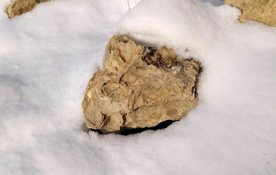
Stromatolites in the snow
To close out 2021, here are some stromatolites in the snow.
|
|
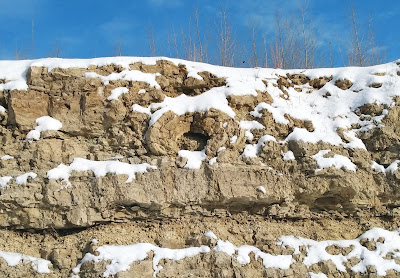
A big stromatolitic eye; no scale bars today (I couldn't reach this one
anyway, but it's a couple of feet across). |
At this location there's a large wall of Prairie du Chien Group rocks that was exposed a few years ago during the construction of a bike trail. The bike trail descends from north to south, exposing more of the section as you go until a few dozen feet of the Lower Ordovician are visible. There is a distinct stratigraphic break near the top of the section, and just above this break is a stromatolitic interval with some large colonies, like the eye-shaped example above. I haven't seen any definite fossils below the break, but there might be some (there are numerous small voids, at least some of which could represent dissolved shells). There are some nice sedimentary structures, though, such as cross-bedding and planar bedding (sand grains in the carbonate).
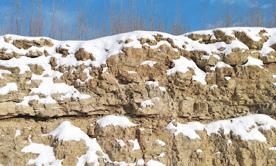
|
|
The center of this photo shows a sort of bi-lobed pillow that smooths
out into a single mound. It is not far from the eye-like stromatolite in
the previous photo. In both cases, the large colony is about a foot
above the stratigraphic break. |
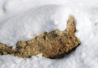
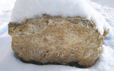
There are also some blocks that have fallen. In fact, I suspect that the stromatolitic interval is more prone to shedding blocks than the rest of the interval, because the stromatolitic interval has more opportunities for fracturing.
Saturday, November 27, 2021
The green rocks of home revisited (now with stromatolites!)
Almost exactly five years ago I posted on a visit to Cottage Grove Ravine Regional Park. I was in the area and thought I'd stop again. There's been a lot of work at the park since then, and I wanted to check that the abandoned stream channel and dry waterfall were still visible. Also, over the past five years I've become much better at finding stromatolites, so I thought I'd try my luck.
Were the landforms still there?

|
|
That's a dry waterfall, all right. The lowest interval seems
to have some weathered cross-bedding; perhaps a somewhat sandier bed in
the Prairie du Chien? |

|
|
I'd say yes, the old channel is still there. |
How about stromatolites?

|
|
We have stromatolites! |

|
|
That's the stuff. |

|
|
Separation has occurred within a stromatolitic interval here. |
At the beginning, I was seeing them in loose blocks, which led to the question "where are they coming from?" This was more complicated. The stromatolitic blocks were much lighter-colored and less weathered, indicating fresh faces. There were no obvious fresh faces on the surrounding walls, though. Had large stromatolitic blocks broken up in the dry stream bed fairly recently? Or were these "plants", Prairie du Chien blocks that had been brought in for landscaping and culvert riprap, then declared surplus and deposited here? The walls were not helping.

|
|
Features like the wavy lines give a general biotic impression, but I'd really want to see some light-colored patches
indicating fallen blocks to cinch a relationship. |

|
|
Fine lines are visible behind the dull gray and moss. |
Then I saw this enormous fallen block.

|
|
Do you see them? They're near center. If not, hold on. |
There they were.

|
|
How about now? |

|
|
A proverbial bull's eye. |
This block is too large and too well-mossed to have been placed here in the past few years. Clearly at least some of the stromatolites are local. I'm still wondering where the loose "clean" blocks came from, though.
Sunday, October 31, 2021
Barn Bluff
One of the outstanding geological sites in southeastern Minnesota is Barn Bluff (He Mni Can to the Dakota, La Grange to the early French explorers*) in Red Wing. The bluff is a bedrock island oriented roughly east–west, adjacent to the Mississippi River just above the Lake Pepin section. If you were to have gone back to the early postglacial period, it would have been a literal island thanks to meltwater filling the Mississippi River valley.
*All of the names are kind of prosaic, actually. "He Mni Can" is "hill, water, wood", "La Grange" or "Lagrange" is "the barn" for its general shape, and the English name is just a translation of the French.

|
|
The view of the south side of the west end. Observant eyes may notice
that the color of the lower outcrops change near the left side of the picture,
from orangish on the left to banded green on the right. Read on for
why! |
Sunday, July 18, 2021
A fossiliferous Prairie du Chien block
The Prairie du Chien Group is great for stromatolites, but not much for other fossils except for localized occurrences of molds and casts of mollusks; see for example the second photo here or the second photo here. You do get lucky occasionally, though. I did not collect the following block myself, nor was it found in situ, but I would be very, very surprised if it did not originate in the Prairie du Chien Group. The most notable aspect about it is this spiral feature:

What is it? A few thoughts:
If you had to pick a second group to find in the Prairie du Chien after stromatolites, it would be snails, and the Prairie du Chien snails do include some large forms that are flat-coiled or coiled in a low spiral, such as Helicotoma and Rhachopea. They're even of comparable size to this.
Some trace fossils spiral, but we can see that the width of the spiral passage increases as it goes out, and animals do not generally increase in girth like that over a short distance unless they handle matter like the Incredible Hulk, so that's not what we have.
Finally, although we usually think of early Paleozoic nautiloids as straight-shelled, there were a few coiled forms, including one known from the Prairie du Chien: Eurystomites. We can see that this spiral seems to separate from the inner coil near the end, and conveniently enough, Eurystomites also gets lax at the end of its coil. However, there's no clear indication of chambers.
What do I think? Without being able to see the entire fossil, you could make an argument that this is an internal cast (steinkern) or external cast of a snail (in which the outer whorl shows separation either because we're looking at the inside or because the plane of exposure isn't low enough to show that the whorl is actually just flaring), or a poor-quality external cast of a Eurystomites or similar nautiloid (can't be internal, because there's no evidence of chambers).
Operating on the principle that where you find one body fossil in the Prairie du Chien, you might find more, I examined the rest of the block, which turned out to have several more easily interpreted molds of much smaller and more obvious snails:
 |
| Low-coiled snail, coiling into the block. |
 |
| A more elongate form; the shell may be slightly sculptured, but relatively coarse mineralization in the mold makes it hard to tell. A similar but less easily photographed example looked much smoother. |
 |
| A pair of shell molds exposed at an awkward angle. |
Sunday, April 11, 2021
Paleozoic Taxa of the St. Croix Valley
Back when I was working on the Saint Croix National Scenic Riverway project, I'd compiled a spreadsheet of all of the fossil genera and species that had been reported from the rocks exposed along the valley. There had been some talk of spinning it off as a separate thing, but that never happened, so I played with the idea of posting it here. I then forgot about it until recently looking through the backlog of half-formed ideas. The spreadsheet itself was all ready to go, so I figured "why not?"
It's pretty simple; a column of numbers so it can be sorted back to the original organization when I'm working, a column for the genus/species, a column for the broad classification, twelve columns for the formations (go here for a refresher; the names are abbreviated for space, but each one has a note providing the full name), a column for references (defined on the "References" tab), and a column for additional notes. If a given species is present in a particular formation, the corresponding cell is marked "Y" and filled blue; if there's some question, the cell is marked "?" and filled yellow. If it's not present, there's a dash and no color fill. To check it out, you can enter here. I would not be surprised if there has been some oversplitting, if for no other reason than the challenges of preservation (we're dealing with a lot of natural molds and casts of partial trilobites in sandstone; fragility and preservation fidelity leave something to be desired).

It's worth mentioning that there is a document that covers some of the same ground, Raasch (1950). In one sense it's more narrowly focused, on Cambrian trilobite biostratigraphy, but in another it's more diffuse, with a larger area of interest.
References
Raasch, G. O. 1950. Zonal range of Croixan trilobite genera in the upper Mississippi Valley. Cambrian Subcommittee Memorandum No. V. Illinois State Geological Survey, Urbana, Illinois.
Sunday, January 24, 2021
Vermillion Falls
As the old story goes, when you visit a place, you go to all the sights, but if you live there, you never get around to seeing them. I decided to play the tourist and see Vermillion Falls in Hastings, which I'd never done despite living about 10 to 15 minutes away most of my life. (And yes, it's spelled with two "l"s here.)
 |
| Partly frozen over, with adjoining industrial facility at the falls itself. |
 |
| Looking down into the gorge from above the falls. |
Vermillion Falls is a waterfall on the Vermillion River, a tributary to the Mississippi. The falls and downstream gorge are actually not unlike a miniature version of the Mississippi gorge from Fort Snelling up to St. Anthony Falls. Aside from scale, the major difference is the steeper walls. Unlike the Mississippi, which has only had to contend with about 15 to 30 feet (5 to 10 m) of Platteville Formation before getting to the soft underbelly of Glenwood and St. Peter, the Vermillion has the task of cutting through something like 100 to 150 feet (30 to 45 m) of genuine Prairie du Chien Group, which hasn't eroded peaceably for anyone in 475 million years and isn't about to start now. The walls of the gorge have been weathered to a crisp.
 |
| Although we can identify several substantial subdivisions, and plenty of beds. |
 |
| Looking downstream within the gorge, from the floor. |
Hastings escaped the attention of the most recent glaciation, so the Vermillion River has had longer to work on its gorge than the Mississippi has in Minneapolis–St. Paul above Dayton's Bluff. Instead, the current incarnation of the Vermillion River postdates the preceding glaciation, the Illinoian, which would make Vermillion Falls's origin about an order of magnitude older than St. Anthony Falls and the other Mississippi gorge falls (i.e., older than a hundred thousand years rather than ten thousand years). Before that, the Vermillion disappears into the hazy web of buried channels beneath the glacial drift. Hastings is surrounded by buried channels, including a massive example south of town cut down all the way into the Franconia (see Mossler 2006 for the layout). In fact, if some evil genius were to remove all of the loose post-bedrock sediment, most of metropolitan Hastings would become a roughly rectangular island. (Also of note: the Hastings Fault only clips the northwest corner of the city.)
 |
| Looking upstream in the gorge toward the falls (not visible due to a bend in the river) from a small bridge. |
 |
| Sneaking a peek from just below. |
References
Mossler, J. H. 2006. Bedrock geology of the Hastings Quadrangle, Dakota, Goodhue, and Washington Counties, Minnesota. Minnesota Geological Survey, St. Paul, Minnesota. Miscellaneous Map 169. Scale 1:24,000.
Sunday, March 8, 2020
Stromatolite Sunday
I happen to know a place along a shore where the riprap includes a small percentage of stromatolitic blocks, and given the nice weather on Saturday, I thought I'd stop by and take some pictures. I have not asked about the source, but I have a pretty good idea that the provenance is one or more quarries in the area working the Shakopee Formation (Prairie du Chien Group). The rocks look like the Shakopee Formation (including that which is exposed in outcrop nearby), and there are no fossils beyond stromatolites and burrows. Stromatolites can be subtle features, but not these examples. Not only is the layering very distinct, once you get used to the appearance of the stromatolitic blocks it is possible to reliably pick them out from the other blocks at a distance of a few meters/yards. The simplest way to describe it is that the non-stromatolitic blocks are sandier and thus reflect light differently. Here's a side of a stromatolitic block, as you might see it as you approach.
You'll see what looks like numerous parallel series of stacked parentheses. Let's zoom in on them:
Enhance!
The stacks aren't necessarily separate columns, because if you look closely you can see that layers can continue from stack to stack, but "column" is a handy quick descriptor. In life, the colony would have had a lumpy upper surface composed of a number of distinct but connected domes. We can see this in upper and lower surfaces of stromatolitic blocks.
I am completely comfortable interpreting these lumpy stacked colonies as Stauffer's Cryptozoon rosemontensis, which he named from the Shakopee Formation not too far away. Almost all of the stromatolitic blocks I saw fall under this category, but there were a couple of examples that did not have stacks, instead having large hemispherical structures. These are much more typical of a variety named Cryptozoon minnesotensis.
Some of the blocks are well-preserved, even though they are now exposed to the elements. Others are now weathering, breaking down either by spalling at the tops of the dome stacks or by the stacks themselves beginning to fall out. The difference may have to do with how much sand was incorporated into the colony.
The Prairie du Chien Group is not noted for its non-stromatolitic fossils, although I have seen some snails in the Shakopee elsewhere. These blocks did not change that overall impression. There were a couple of cases of burrows or things that look very much like burrows, though.
 |
| Since these are domes, way-up is toward the top of the photo. |
You'll see what looks like numerous parallel series of stacked parentheses. Let's zoom in on them:
 |
| Note that the column near the center splits into two smaller columns going up. |
Enhance!
 |
| There's been just enough weathering to make the layers stand out nicely. |
The stacks aren't necessarily separate columns, because if you look closely you can see that layers can continue from stack to stack, but "column" is a handy quick descriptor. In life, the colony would have had a lumpy upper surface composed of a number of distinct but connected domes. We can see this in upper and lower surfaces of stromatolitic blocks.
 |
| The upper surfaces of stromatolite blocks (A) are lumpy, showing the tops of the small domes. Sometimes there is a nice bottom surface that's essentially a negative of the upper surface (B). (These are definitely hollows, but your eyes may interpret the photo as domes.) Bottom surfaces can be easier to appreciate than the sometimes subtle upper surfaces. |
 |
| In this case, weathering has partially removed some of the uppermost layers, "dissecting" the tops of the domes. |
 |
| This photo, taken along the edge between an upper surface and a side, shows how the stacks translate into domes. |
I am completely comfortable interpreting these lumpy stacked colonies as Stauffer's Cryptozoon rosemontensis, which he named from the Shakopee Formation not too far away. Almost all of the stromatolitic blocks I saw fall under this category, but there were a couple of examples that did not have stacks, instead having large hemispherical structures. These are much more typical of a variety named Cryptozoon minnesotensis.
 |
| These two photos show a much different flavor of microbial colony immortalized as stromatolites. A shows multiple lobes, while most of B is one big dome. These are in the vein of Cryptozoon minnesotensis. |
Some of the blocks are well-preserved, even though they are now exposed to the elements. Others are now weathering, breaking down either by spalling at the tops of the dome stacks or by the stacks themselves beginning to fall out. The difference may have to do with how much sand was incorporated into the colony.
 |
| This group of photos shows a heavily eroded block, with columns beginning to spall out. A gives the overall appearance. B is a close-up of several such columns. The pockmarks mark where sand grains have eroded from the layers. C shows a closer view of pockmarks. |
The Prairie du Chien Group is not noted for its non-stromatolitic fossils, although I have seen some snails in the Shakopee elsewhere. These blocks did not change that overall impression. There were a couple of cases of burrows or things that look very much like burrows, though.
 |
| A couple of examples of burrows or burrow-like features. A has a long feature from the lower left to near the center, plus other shorter similar features. B has what looks like a web of burrows. |
Subscribe to:
Posts (Atom)